Almost every vehicle in the world emits a radiosignal. This applies to cars, planes, ships and almost all vehicles. These radio signals can be used to locate these vehicles with a simple device like the RTL-SDR.
Almost all aircraft must be equipped with an ADS-B transponder. The aircraft then transmit an ADS-B signal (on 1090Mhz) which can be used to locate their position and altitude.
Websites like Radarbox and others sell a simple ADS-B receiver to people all over the world and then it feeds data in by clicking here their. You can do the same for your area with a simple and flexible, RTL-SDR.
ADS-B Out works by transmitting information about an aircraft's GPS position, altitude, ground speed and other data to ground stations and other aircraft once per second.
ADS-B Out airspace and equipment requirements are contained in 91.225 CFR § 14 and equipment performance requirements in § 91.227. ADS-B In provides operators of appropriately equipped aircraft with weather and traffic position information delivered directly to the cockpit.
You only need the RTL-SDR (about $40 on Amazon) and the free software to decode this signal.
Step#1: Download software
First make sure the RTL-SDR is connected to your system (lsusb). Then you need to download the software from the following link.
kali > sudo git clone https://github.com/antirez/dump1090
Or you can do what I did and download DragonOS, a Linux operating system designed specifically for SDR Hackers. It is available here.
https://sourceforge.net/projects/dragonos-focal/
This OS is great! It is designed specifically for SDR, with most of the great apps and all their dependencies. I like this OS so much that I will be using it for all projects as well as SDR drivers.
Step #2: Run dump1090
Now with DragonOS or dump1090 software installed on another machine Linux, navigate to the dump1090 directory.
kali > cd dump1090
Now, just type the command,
golden dragon > ./dump190
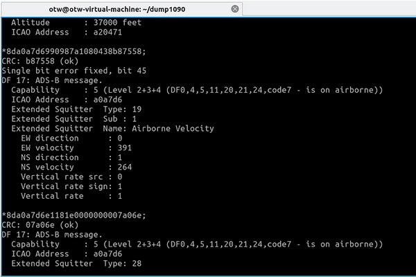
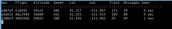
As you can see above, the RTL-SDR receiver and dump1090 software provide you with all ADS-B data available in your area, including GPS coordinates, altitude and ground speed.
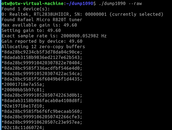
If we are only looking for the unformatted raw data, we can simply use the –raw switch.
dragon> ./dump1090 –raw
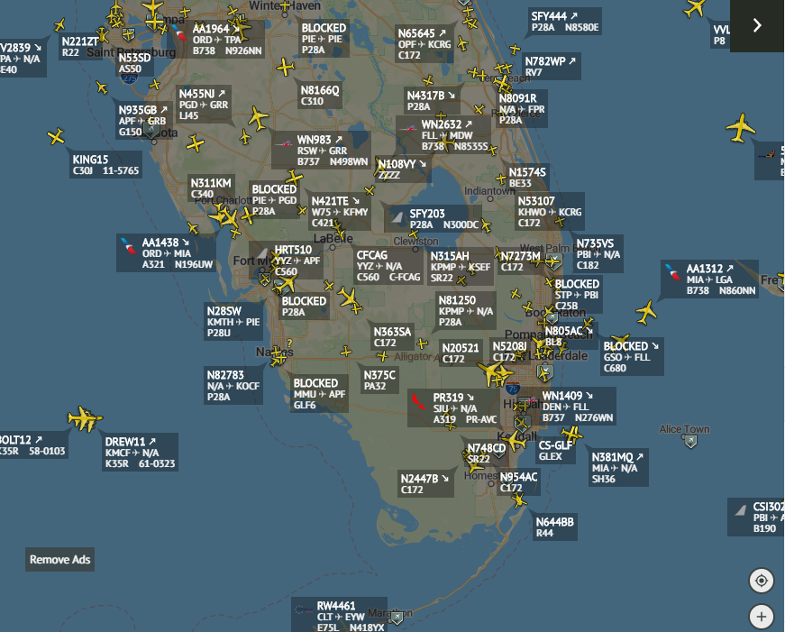
For a more interesting view of the data, we can use the –interactive switch as below. Here dump1090 provides us with an interactive table of flights in the area that is updated every second.
dragon> ./dump1090 –interactive
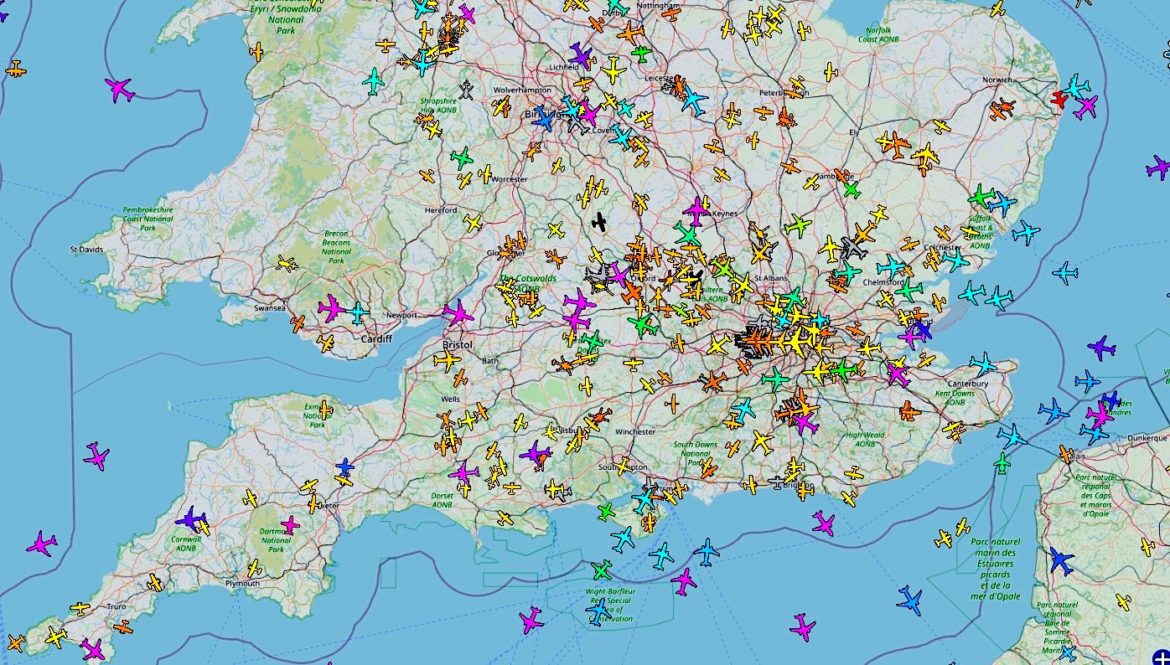
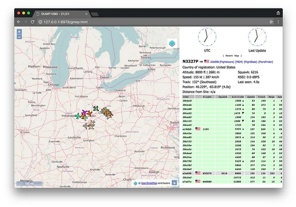
Perhaps the most attractive graphical display of aggregate data and is similar to radarbox. With this switch, the data is overlaid on Google maps. This way, we can actually track flights in real time on a map of our area.
To track the graphical data on a map, simply type,
./dump1090 –interactive –net
Then open your browser and navigate to localhost:8080
This will open an interactive map with all the aircraft in your area (your map may differ slightly).
Summary
Each airplane sends out an ADS-B signal that can be used to locate the position and altitude of the flight. With some free software like 1090dump and an inexpensive receiver like the RTL-SDR, we can locate all flights within our receiving range (this depends on many factors, including your antenna).
This is yet another example of the power of SDR for hackers!

For those who want to engage in this hobby, I provide a link with rich topics and programs for all platforms, concerning the magic chip and the RTL-SDR area
https://www.rtl-sdr.com/big-list-rtl-sdr-supported-software/